Drove to Ulsan 울산 to attend cousin's wedding ceremony on the 3rd Saturday in December. It's been quite a while since I was there. Ulsan is located on the southeastern coast of the Korean peninsula, which is the largest industrial city in South Korea. It has a famous football stadium named Munsu 문수 and opened in 2001, where several 2002 FIFA World Cup matches were hosted.
The wedding hall is inside the stadium, just below stands. The stadium has a subsidiary park around, which offers views of the western outskirts of Ulsan from the hill.
Street scenes last weekend in the Seongseo Industrial complex on the eastern Daegu. Lots of gingko and plane tree leaves falling on the streets in front of many different kinds of factoriesshowed that this autumn has deepened. Nature is preparing for winter, which is just around the corner.
Hwangseong Park 황성공원 is a wooden park in the middle of Gyeongju city. The forest consists of pine and oak trees. It used to be a military training camp for the elite youth during Silla dynasty. This area has been well conserved for a long time, whose trees also remain intact. The park is located next to Bukcheon 북천, the northern river penetrating the northern Gyeongju. To the north of the park, paddy field, orchards and some small villages scattered here and there a couple of decades ago. There used to be also a gravel runway for small airplanes between Bukcheon and the park. Then Bukcheon was so clean that it turned into a big swimming pool for kids in the hot summer. The urbanization around the park, especially to the north, had started earlier. Now the park faces a line of commercial buildings and apartment complex to the north. After a new dam was constructed in the upper river about 40 years ago, Bukcheon has been polluted and not suitable for swimming in Summer any longer. Hwangseong Park still remains like a jewel for all though.
Went for a hike to enjoy the deepening autumn around the skirt and took some random photos. The above is a view from the observation tower in Hwawon resort 화원 유원지 on the eastern Daegu.
Hwawon resort 화원 유원지 is set just by the confluence of two rivers, the Nakdong river 낙동강 and the Geumho river 금호강. The photo on the left is about the two rivers, the bigger one on the left is Nakdong and the other on the right Geumho. The photo on the right is the path up the observation tower on the top of the resort.
Just after mid-August, it gets cooler and cooler. The scorching summer seems final to be over. Koreans are eventually relieved from the terrible heat and humidity. Actually, every time summer comes, many people like me sensitive to the heat and sweating a lot worry about how to spend the summer. Summer 2016 in Korea felt even hotter than last. The tropical nights and heat wave hit the country and people seriously struggled to cope with the heat day and night. Took some pics to memory the unprecedented heat in the summer of 2016. The temperature rose up to 42℃ outdoors on Aug. 14, as shown the above.
Headed for Gyeongju on Aug. 12 to spend the summer holiday. It happened that the hottest area across the country on that day was just the ancient city, whose temperature was 39.4℃. The cool places downtown like air-conditioned coffee shops were packed with people to avoid the intolerable heat. Took a photo in front of Cheomseongdae 첨성대, an ancient astronomical observatory built in Shilla dynasty.
An American recalled his childhood in Korea about 50 years ago when he had visited Cheomseongdae. He left a comment on Youtube: "Wow does that take me back Steve! I saw Cheomseongdae when I was 12, back in 1965! My family went with another military family from Daegu in their van. As I remember, the road was gravel all the way there. Also funny - people constantly were trying to flag us down as they mistook the big American van for a local bus. Imagine their surprise when the "bus" stopped and it was full of Americans!" Two US military camps have been located in Daegu. In the past, most of the roads in Korea just as the same one the American child saw were made of gravel, so they were so bumpy and rough. I also remember the bumpy and dusty road from Daegu to Gyeongju.
Spent last weekend hiking around the western outskirts... In the morning I left home to head out for a short hike just outside Seongseo Industrial Complex on the western Daegu. It was cloudy in the morning and cool, but getting hotter when the sun started to shine. The trail goes straight on the bank of the Geumho river. Hiked to the nearby mountain where the trail disappears over the horizon as shown photo above. People named that Gungsan 궁산 meaning a bow-shaped mountain. Sometimes a few walkers, cyclists on bikes, runners and dogs with their owners pass by.
A traditional building at the bottom of the mountain comes into view if you keep walking north and pass under Gangchang bridge. The river flows past the rocky cliff on the left. People usually take the trail by the building to start hiking right up to the mountain and should go uphill from the start. Once you walk up, the trees block the sun's heat and the cool breeze blows through them. The left photo shows the view of the top and the other one the scene from the top overlooking the southern area, from which the trail in the photo at the top is dimly visible in the distance.
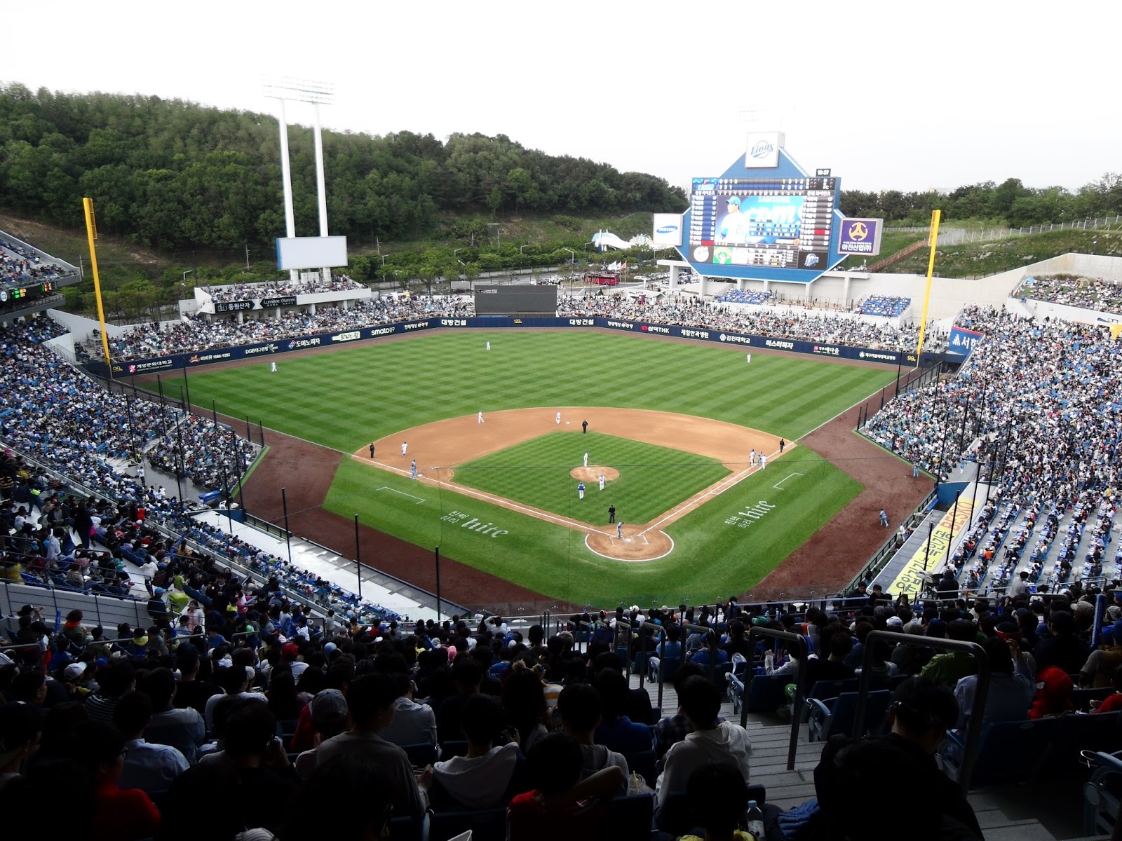
Last Saturday, there was a pro baseball match between Samsung Lions and Lotte Giants at the brand new Samsung Lions Park to the east of Daegu. The second match between Lions and Giants started at 5: 00 p.m. during three consecutive home matches. The stadium was filled with enthusiastic singing and chanting by the fans, which is most likely to be the cultural difference in baseball fans between Koreans and Americans. Major league baseball fans from North America have begun to take an interest in Korean baseball and enjoy the exotic and unique atmosphere together.
Pro baseball has become the most popular sports in Korea since its inception in 1982. We currently have 10 pro baseball teams in Korea. Daegu is the hometown of Lions, while Busan Giants. The infrastructure has improved hugely as well. Samsung Lions Park is the long-awaited new stadium for the baseball fans in Daegu.
Last weekend, I went for a hike to the nearby mountains by myself, walking from home as usual,and took photos of random scenes about the changing season. The leaves have turned yellow and brown as the autumn deepens. Leaves falling down scattered on the ground. Looks like this autumn there has been much more rain than in previous ones. We also had a couple of rainy days last week. It didn't rain while hiking, even if it was cloudy. Walked along the path for 5 hours and reached a riverbank called Dalseongbo weir. Got back home after half an hour on foot and by local bus. Hiking really helps recharge one's batteries after a busy week at work.
A small, peaceful town, Namji 남지 in the southern province of Changnyeong 창녕 county, is just by the bank of Nakdong River. Namji Bridge was built in February 1933 during the Japanese occupation, which was on the road from Daegu to Masan. The photos show the view from the top of the southernmountain, which were taken by an American war correspondent in August 1950 during the Korean war, and the right side one depicts the bridge being destroyed in the same month, which was intended to stop the North Korean People's Army from crossing. It has been estimated that this used to be one of the most important and beautiful iron bridges in the peninsula. Plus, it was built using new construction techniques as applied to the Eiffel Tower in Paris. The tiny northern village across the river is Namji.
The areas around Namji Bridge were prone to floods. In the summer of the year 1933, the flood struck the northern villages, and thousands of villagers had to evacuate to the nearby mountains at midnight. The road connecting to the bridge was also washed away, so it was completely closed to traffic for two months in the same year the bridge was completed. The bridge was used by both pedestrians and vehicles until 1994. It is now open only to pedestrians. In 1977, a new bridge for the expressway from Daegu to Masan was constructed nearby.
These photos show the bridge as it looked last summer. The top is the southern entrance to the bridge. The mountain on the right side is the spot where the American war correspondent took the photo of Namji Bridge about 65 years ago during the war.
A small town named Samnangjin 삼랑진 is around the confluence of two rivers, the Nakdong river 낙동강 and the Miryang river 밀양강. Samnangjin refers to a river dock where choppy water fed by three tributaries flows over the surface. Since Shilla dynasty(57~935 AD), a river dock located here had actually played a principal role in the water transportation route along the Nakdong river.It later became one of the largest docks along the Nakdong River during the Joseon Dynasty(1392–1910), where its role as a tax collection center was particularly emphasized. and it had a prosperous period in its history. The tax was usually paid in grain, cotton cloth, and coin. In 1765, a tax warehouse named Jochang 조창 was opened on the riverside at the confluence to store the taxes collected from 6 regions, including Miryang, Gimhae 김해, and Hyeonpung 현풍. Jochang refers to a warehouse for taxes arrived by ships. This route was linked to Samunjin 사문진 and Gangchang 강창 river docks.
A railway station was opened 3 km inland northeast of Jochang in 1905. Since overland traffic was introduced, the water transportation route had decayed. Jochang was closed, cherishing old memories, and the town center was moved to Songji 송지, nearby, where a railway station was built. However, Samnangjin had flourished again since the railway station became a junction, which is connected to Seoul서울, Busan 부산, and Masan 마산.
During the Japanese colonial period, Samnangjin railway station had a big official residence for railway workers, which still remains partly renovated on the gentle slope to the north of the station. The residence features unique stone-and-cement walls, as in traditional Japanese castle architecture.
Meanwhile, since the first track had been partly relocated, the single-track bridge named Samnangjin bridge near Jochang was abandoned. Now it is still one-way car traffic or used by cyclists. It was nicknamed"Bridge on the River Kwai" in Thailand. The old rusty iron railway bridge is often called that in Korea.
Samnangjin was also located on the key walking route to Seoul and Busan during Joseon Dynasty. The trail still remains partly on the steep mountain slope by the Nakdong river, which is called Jando잔도. There is a bike path built right out over the water.
The Nakdong 낙동강 and the Geumho 금호강, meet around Hwawon resort. The smaller one, Geumho flows into Nakdong, the longest river in the southern peninsula. Shincheon 신천, the urban stream in Daegu is a branch of the Geumho river.
The Geumho river separates western Daegu from Dasa 다사 district. A bridge connects the two at Gangchang 강창 meaning a riverside storage; gang 강 is river, chang 창 storage. In Joseon Dynasty(1392~1910 AD), sea and rivers were the main routes to transport the tax collected locally to the government in Seoul. Gangchang was a riverside storage where the tax amount was stored temporarily. Tax collecting ship used to come to pick up the stored tax earlier every year. The tax was usually paid with grains of rice.
Small boats had been also operated to transport locals to the other side of the river since the ancient times. The boatshad been the only way for the locals to cross the river until a new bridge named Gangchang was built in 1971. The very top photo on the left shows a ferry boat crossing the river and the other one locals joined the opening ceremony of Gangchang bridge to celebrate.
The first bridge is not here any longer and has been expanded and renovated twice since 1971. The above ones are views of the present bridge opened in 2009, which has ten lanes. Gangchang used to be a typical countryside as the other villages around the city. It had peaceful scenery along the stretch of riverside with sands and tall trees, and traditional houses were scattered here and there along the dusty road. As urbanization occurred, however, the landscape is not just as it was in the past. Only the nearby mountains look the same as past.
The eastern coast of the Korean peninsula has a hiking trail covering 688 km(428 miles). Since this route offers a beautiful and peaceful view of seashore along with the blue color of East Sea, it is called Haepargang Gil 해파랑길; Hae means sea, Parang blue, Gil trail. The whole route separates into 10 sections belonging to 10 administrative regions.
Yeongdeok 영덕 County as one of 10 sections has its coastal trail covering 62.9 km of rugged terrain along the coastline. From nearly every point on the trail, hikers are enthralled by the blue sea with the panoramic horizon. The trail passes through some rocky areas and is rugged with some steep sections. Plus it runs through peaceful and rural coastal villages and tiny harbors. Since the trail is man-made recently, not treading trodden trails for a long time, you should watch your step sometimes.
Every year in March or April, Yeongdeok holds a festival to attract tourists loving Daege(snow crab) 대게 across the nation and abroad. The above one shows the official poster for this year's festival.