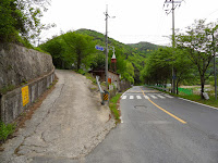
Winggye 윙계 is the name of a side valley in the southern mountain area in Daegu 대구. Winggye means a valley on the left side; wing means "left", a dialect of wen 왼 and gye "valley." On the way to Jeongdae-ri 정대리, a remote village at the bottom end of the main valley, the road branches off to the left and gets narrower, finally turning into a mountain trail that becomes a little vague. In the past, when public transportation was not available, locals used to walk along this trail in the middle of this valley. The above photo was taken last May at the entrance to Winggye; the ones below were taken at the same place and around the valley this spring.
This walking trail connected western Daegu with southern regions such as Cheongdo 청도 and Miryang 밀양. Since this area is surrounded by mountains, the ancient people traveling through this region seem to choose the lowest pass along the ridge. Winggye is really the finest choice for them to cross this mountain area. Older villagers, who have lived in the area for decades, recall that the trail used to be jam-packed with travelers. Since the new road opened, it has become almost deserted.
It was getting warmer. Cherry trees came into bloom. Winggye Jae 윙계재 is the name of the pass across the mountain ridge, between Winggye and the other side of Cheongdo province; Jae 재 means "pass." Heading southwards, the trail leads up the gentle slope and becomes steep near the ridge. Trail markers sit on the ridge pass. Four trails lead out from the pass.
Songnae 송내 is the first village that you should reach when you go southwards down the mountain along the trail from Winggye Jae. There used to be a couple of traditional taverns for the travelers in this village who were going to cross the pass or came across it. The pavilion in the photo above, located behind the boulder, marks the site at which a tavern once stood. To its left is a stone stack called Seonangdang 서낭당, which was dedicated to the village guardian deity in local folk belief. Travelers would place stones on the stack and pray for a safe journey, believing that the deity would protect them along the road.
Looking at the mountain range from spring field in the southern district, Gakbuk 각북, you can see Winggye Jae, the lowest spot on the ridgeline in the distance. Walking along the ancient tracks trodden for thousands of years has encouraged people to contemplate life and its meaning.
Heading further southwards, you may reach a bit bigger town named Punggak 풍각. In the old days, people passing near here were likely to stop off at some inns accommodating them with a night's lodging. It takes about 7 and a half hours on foot from western Daegu to here, but the suburban bus covers the distance within half an hour. The photo above shows a bus to Daegu waiting to depart outside the Punggak Bus Terminal, which is currently under repair.


